DOUBLE-MASTER-DEGREES PROGRAM of University of New South Wales and Shandong University of Science and Technology
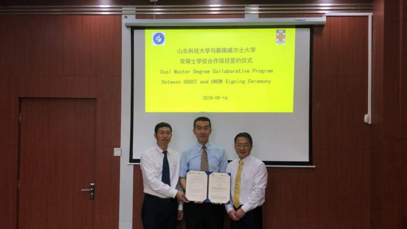
University of New South Wales in Australia and Shandong University of Science and Technology
澳大利亚新南威尔士大学与山东科技大学
DOUBLE-MASTER-DEGREES PROGRAM
双硕士学位项目
1. Objectives of the Program 项目目标
The Double-Master-Degrees Program comprising the Master degree program from SUST and the Master of Philosophy (MPhil) degree program from UNSW will be an attractive value proposition for research students of both universities and will enhance research collaboration between UNSW and SUST. It will adopt all the aims and objectives of the two separate Master Degree programs.
双硕士学位项目包括山东科技大学的硕士项目和新南威尔士大学的研究型硕士学位项目。该项目对双方学校研究生来讲无疑将是一个极具吸引力的价值主张,同时也将增进双方学校的科研合作。
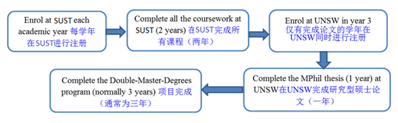
2. Program Pathway 项目课程设置
A student at SUST may undertake the Double-Master Degrees Program by using the following pathway:
- Complete all the coursework at SUST (2 years) followed by completion of MPhil thesis (1 year) at UNSW;
- The candidature period for the Double-Master-Degrees Program is normally 3 years.
SUST学生可通过下列方式完成双硕士学位项目:
- 在SUST完成所有课程(两年),之后在UNSW完成研究型硕士论文(一年);
- 项目完成期限通常为三年。
3. Admission Requirements 入学条件
Candidates have to fulfil the admission requirements for both universities in order to gain admission to the Double-Master-Degrees Program.
申请人必须满足双方学校的入学条件方可有机会参与双硕士学位项目。
4. Enrolment and Tuition Fee 注册和学费
The Double-Master-Degrees Program student shall (re-) enroll at SUST each academic year and at UNSW only during the MPhil candidature. S/he shall pay the tuition fees charged for the Master program at each institution stipulated by the institution.
项目学生每学年都应在SUST进行注册,仅有完成论文的学年在UNSW同时进行注册,并需按双方学校规定缴纳学费。
5. Graduation Requirements and Degrees 毕业条件和学位
Students must satisfy all the requirements (both coursework and thesis examination/thesis defense) of the individual Master degrees at both institutions. The MPhil thesis may be supervised jointly by UNSW and SUST staff. The Masters thesis may be supervised jointly by SUST and UNSW staff. Upon successful completion of all the requirements, students will be awarded with both UNSW MPhil and SUST Master degree.
学生必须分别满足双方学校的硕士学位要求,包括课程、论文、考试和论文答辩等。UNSW研究型硕士学位论文将由UNSW和SUST双方导师共同指导。SUST硕士学位论文将由SUST和UNSW双方导师共同指导。在完成双硕士学位修读后,UNSW按其规定颁发其研究型硕士学位,SUST按其规定颁发其硕士学位。
6. Program Coordinators 项目负责人
- Prof. Xiao Hua Wang (王小华教授) in UNSW
- Prof. Fanlin Yang (阳凡林教授) in SUST
7. Program Contact 项目联络
Prof Xiao Hua Wang
Director
The Sino-Australian Research Consortium for Coastal Management
UNSW Canberra at the Australian Defence Force Academy
PO Box 7916
Canberra BC ACT 2610
Australia
Email: sarccm@adfa.edu.au
Website: http://pems.unsw.adfa.edu.au/SARCCM
Prof Fanlin Yang
Dean
College of Geomatics
Shandong University of Science and Technology
No. 579, Qianwangang Road, Huangdao District
Qingdao, China
Email: flyang@126.com
8. Prospective projects for SARCCM UNSW-SUST Double-Master degrees program candidates 项目的研究方向及导师信息
8.1 Oceanography
Supervisor: Prof Xiao Hua Wang
Fluid mud layers in the Changjiang (Yangtze River) estuary
This project will characterize the fluid mud layers in the Changjiang estuary and develop new numerical models to investigate these layers. It will examine the role of the fluid mud layers in determining coastal ocean dynamics and in transporting sediments from the river to the East China Sea.
Sediment transport dynamics in the Great Barrier Reef, Queensland, Australia
Due to land clearance and grazing in the catchment areas of the Great Barrier Reef (GBR) rivers, the inshore regions of the GBR are subject to enhanced fluxes of suspended sediments from river runoff, causing bleaching and disappearance of nearshore coral reefs. This project will, for the first time, combine observation and numerical models to investigate the sediment transport dynamics in the GBR region. By quantifying the sediment transport and defining its pathways from rivers to the outer shelf of the GBR, the proposed research will directly address the water quality issues of the GBR, thus help to better evaluate the impact of the land degradation on, and manage and protect the GBR marine ecosystem that offers Australia with tremendous economic, social and cultural values.
Supervisor: Prof Moninya Roughan
Seasonality of submesoscale processes in the East Australian Current:
Sub mesoscale eddies form on the inside edge of western boundary currents and drive productivity through cyclonic rotation and retention. Using output from a 10 year high resolution ROMS simulation of the coastal ocean along SE Australia the student will investigate variability and seasonality of submesoscale dynamics in the East Australian Current. The student will learn about dynamics of the coastal ocean and while learning skills such as how to manipulate model output using software such as Matlab.
What are the main factors driving biological variability on the continental shelf?
Fluorescence measurements (a proxy for chlorophyll) obtained from 5 years of oceanographic moorings on the continental shelf of Australia will be analyzed and related to the physical oceanographic conditions (temperature, salinity) and forcings (wind, current, eddy encroachment).
Required skills: Some knowledge of Physical oceanography and statistics; Matlab or Python programming.
Supervisor: Dr Jan Zika
Regional sea-level rise: warming oceans or ebbing currents?
Changes in the frequency of extreme sea level events are set by changes in regional sea-level patterns. Projections of those changes are highly uncertain. Regional sea-level change patterns are caused predominantly by two processes: 1) heat being added to the ocean and 2) ocean currents changing direction (ebbing and flowing). Knowing which is controlling the patterns of change is key to developing more accurate projections. The student will analyze exciting new data from a range of state-of-the-art climate models from around the world. Novel modelling techniques will allow the student to quantify the contribution of ocean circulation and heat content to regional sea level change and help to improve model projections.
Linking the seasonal cycle of ocean water masses to transient climate change
The process of seasonal ventilation dictates the ocean’s role in climate - both present and future. Only in the last decade has a systematic understanding of seasonal ventilation become possible due to the presence of thousands of autonomous buoys (ARGO) and satellites measuring upper ocean temperature and salinity. Likewise never has the need to quantify it been more pressing.
This project will combine the latest observations to generate a quantitative picture of the formation, ventilation and destruction of cold dense water masses in both hemispheres. A key novelty of this project will be the use the water-mass transformation framework. Using this framework variability in water mass properties into that due to surface heating and cooling, evaporation and precipitation, mixing and energetic drivers such as wind forcing.
8.2 Remote Sensing
Dr Zhi Huang
Sensitivity analysis of the Himarwari-8 data in measuring SST diurnal variation
The Himawari-8 (H-8) is a new generation geostationary satellite carrying an Advanced Himawari Imager (AHI), capable of providing geophysical data at a spatial resolution of 2km and a temporal resolution of 10-mins full-disk frequency to resolve SST diurnal variation. Despite its great potential, the sensitivity of the existing H-8 SST products to the true SST diurnal variation needs to be tested. This project aims to conduct sensitivity analyses of several existing H-08 SST data, from JAXA, BOM and NOAA, in measuring SST diurnal variation. The in-situ SST data will be obtained from the drifting buoy SST data from iQUAM v2.0 to calculate the “true” SST diurnal variation. The spatial domain of the project covers the entire spatial coverage of the H-08 data. The temporal domain covers the last four years since Aug 2015. The results of the sensitivity analyses would enable us to evaluate the relative accuracies of these H-8 SST products in terms of estimating the true amplitude of diurnal SST.
Error analysis of the Himarwari-8 data
The Himawari-8 (H-8) is a new generation geostationary satellite carrying an Advanced Himawari Imager (AHI), capable of providing geophysical data at a spatial resolution of 2km and a temporal resolution of 10-mins full-disk frequency. The H-8 SST data have been used in increasing numbers of oceanography and ecological studies. However, uncertainty of the H-8 SST data, for example its bias and standard deviation against true SST, has not been comprehensively assessed. This project aims to conduct error analyses of several existing H-08 SST data, from JAXA, BOM and NOAA. The in-situ SST data will be obtained from the drifting buoy SST data from iQUAM v2.0 to represent “true” SST. The spatial domain of the project covers the entire spatial coverage of the H-08 data. The temporal domain covers the last four years since Aug 2015. The results of the error analyses would enable us to evaluate the accuracies of these H-8 SST products.
Supervisor: Dr. Yue Ma
Estimating water levels and volumes of main lakes (reservoirs) at a global scale
As a subset of the Earth’s surface water, lakes and reservoirs store fresh water and make it available to life and industrial, irrigation, hydropower, wetlands, and environmental water use sectors. In the past years, the water levels and volumes in most of the 168 main lakes in Australia underwent decreasing trends in the past 30 years, and the same trend is in China, Canada, Alaska, and Siberia. In this project, at a global scale, the temporal change in water levels and volumes of main lakes (reservoirs) from 1980s to present will be precisely estimated with only remotely sensed data (including Landsat imagery, satellite radar/laser altimeters, and photon-counting lidar datasets) and evaluated by some in- situ measurement. How can the surface profiles of the ground and the underwater bottom be extracted from the raw lidar data? How can the lake boundaries between land and water in different years be detected from the satellite imagery? How the multiple datasets be fused to calculate the water levels and volumes? And How can the mass data be effectively processed?
Remote sensing of sea state using satellite photon-counting lidars
In coastal areas, the footprints of traditional radar altimeters are very large (normally several kilometers in diameter), which introduces trouble to distinguish the sea surface from the land. As a result, the parameters of sea state (e.g., mean sea levels, mean sea slopes, significant wave heights) cannot be precisely extracted in coastal areas. With much less footprint size (several meters in diameter) and higher footprint density, the data of satellite photon-counting lidar is a promising solution to extract the sea state parameters in the coastal areas. How can the signal photons be extracted from the noisy raw data captured by a photon-counting lidar? How can the signal photons on sea surface be distinguished from those on land? How can the sea state parameters be calculated using the signal photons? And How can the tide effect be offset when calculating the mean sea level?
Monitoring coastline changes at a national scale
As the boundary of land and ocean, coastline is an essential indicator of the coastal ecosystem and environment. Monitoring the coastline change at a national scale is not only helpful to uncover the coastal change, but also provide a basis for coastal land planning and resource sustainable development. In the past years, the coastline of Australia experienced temporal changes with coastline retreat and expansion caused by different natural factors and human activities. In this project, at a national scale, the temporal change of Australia’s coastline from 1980s to present will be estimated with remotely sensed data (including Landsat data, MODIS data and sentinel 2 data) and evaluated by some in- situ measurement. How to extract accurate information of coastline from remotely sensed data at a national scale? How to detect the temporal change of coastline from multi-temporal remotely sensed data? How to estimate the long-term trend of coastline change? And how to explain the coastline change in Australia by combining coastal hydro-dynamic models and in- situ data?
8.3 Coastal Management
Supervisor: A/Prof Stuart Pearson
Blue Economic Zone
What is the Blue Economic Zone and what will its success bring to society, environment and economy? How will it be monitored and evaluated? What does this show about the research needs for China’s environmental law, science and management? [with Ma Yingjie and Chen Shengnan]
Eco-compensation
Why is eco-compensation so popular in China? What does this show about the research needs for China’s environmental law, science and management? [with Ma Yingjie]
Risk in environmental matters
How is risk of environmental research, environmental management and environmental policy considered in Australia and China? How does this contribute to biofuel policy? [with Dong Bo] How does this contribute to Antarctica’s research programs? [with Maozeng Jiang]
Values and attitudes towards the environment
Who cares? Using a social science approach, how can the values, attitudes and dreams of Australia and China’s young professionals be understood and what scenarios can be plausibly developed? Environmental research, environmental management and environmental policy considerations of young people in Australia and China. How does this contribute to government research? [also with Dr Xin Liu Yantai Institute and NSW Government]
Transitions in natural resource management
How widely and how appropriate is applying the Kuznets curve thinking in China a rational Natural Resource Management response? China’s rapid development and transition to a eco-civilisation is widely discussed as a stage requiring ‘development first and clean-up second’. What is the nature of the evidence used by narrators to justify this and what are the plausible scenarios?
Developing the matrix of users in harbours and identifying opportunities for conflict management
The objective of this project is to improve the understanding of research impact and the drivers of research investment in natural resource management in harbours. The impact of research done on natural resource management in harbours (the management of water, sediment, fisheries stocks, biodiversity and other ecosystem goods) is a fertile area that offers benefits to private and public investors around the World. However, it is also challenging to track the impact of the research investment. Because of complexity in attribution, spill-overs, discounting and program design there is considerable confusion about the marginal returns on additional research investments. There is a need to better understand how research impact can be evaluated and how improvements can be included in ongoing research programs. In this project students will develop specific case-study insights into the ways research programs procure knowledge to achieve impact from the triple bottom line perspective (social, environmental and economic)
Plausible futures for China’s harbours
Developing future scenarios is a popular activity to gather insights and build consensus on actions to increase the probability of harbours meeting stakeholders desired futures. How are these scenarios developed in Australia and China? What contribution can futures make to the way other harbours around the world are managed?
Plausible futures for Australia and China ocean policy
Does comparative analysis of Australia and China’s marine resources management approaches and scenarios for the future improve the understanding of the drivers in Australia and China’s approaches to Ocean (or Coastal) management and develop credible future scenarios to inform discussion? Complete an environmental scan to develop a systematic understanding of the drivers of ocean (or coastal) policy in Australia and China with a focus on the slow-moving variables and possible triggering events. Develop a set of scenarios that are built out of the existing evidence and trends to discuss and publish as a tool to identify opportunities and threats in Ocean policy.
The legal values of bivalves in harbours
Mussels, oysters and other bivalves in harbours that are contaminated serve an interesting legal dilemma that relates to social, economic and environmental values. The discussion of different values held by fishers, manager, government agencies and others have a legal perspective. The value of bivalves in the experience of law and the legal potential of bivalve-related law needs to be carefully considered as harbour develop, as social and economic changes occur and as the science and policy evolve. How can harbours be resilient to pressures on bivalve-related legal action? Other related topics that could be developed in this area include:
- The compensation of wild bivalve fishers in harbours?
- Using bivalves as communication objects in harbours?
- Would legal reform assist resilience of bivalve-dependent fisheries?
- Globally, bivalves are used as contaminant filters and sensors, the next steps are problematic. What works in using bivalves in Harbours?