Research Facilities
SARCCM has excellent research facilities including oceanographic equipment such as current meters, ADCPs (Acoustic Doppler Current Profiler), ADVs (Acoustic Doppler Velocimeter), Nephelometers, thermistor chains, tide and wave gauges, CTDs (Conductivity-Temperature-Depth sensor), water and sediment samplers, a new water quality laboratory equipped with an ICP-OES (Inductively Coupled Plasma Optical Emission Spectrometry), and high performance workstations, with access to the supercomputers in the NCI (National Computational Infrastructure) National Facility (Gadi) at the Australian National University.
SARCCM is within UNSW’s areas of research strength: Water, Climate, Environment and Sustainability.
Service Section
- Marine Fieldwork Service
- Customized survey plans for specific oceanographic and marine construction projects.
- Development of a three-dimensional ocean observation network for comprehensive data collection.
- Integration of advanced technologies and methodologies for accurate results.
- Consultation to understand customer requirements.
- Proposal of a detailed survey plan, including timelines and cost estimates.
- Implementation and monitoring of the survey network.
- Cost-effective and scalable solutions.
- Enhanced data accuracy and coverage for informed decision-making.
- Objectives: The field studies were focused on designing a network of marine survey stations in Batemans Bay and Sydney Harbour, two ecologically sensitive and important areas in southeastern Australia.
- Significance: Both areas are key to supporting biodiversity, marine conservation, seascape restoration, dredging and dumping, and regional fisheries. The goal was to create a reliable monitoring framework to track the health of marine ecosystems, assess water quality, and observe seasonal variations, including changes related to climate change.
- Design and Methodology: The design involved placing autonomous data collection systems at strategic locations within both locations. These systems included moored buoys with sensors to measure water quality parameters, including temperature, salinity, dissolved oxygen, turbidity, waves, tides, and currents. The stations will be capable of continuous monitoring with real-time data transmission, ensuring the long-term availability of information.
- Ocean Instruments and Equipment
- XY-NTU Turbidity Smart Sensor
- XY-DOY Dissolved Oxygen Sensor
- XY-CHL Chlorophyll Smart Sensor
- Reliable and durable equipment from trusted manufactureres.
- Competitive pricing and after-sales support.
- Customizable solutions to meet specific project needs.
- Numerical Ocean and Sediment Modelling
- Ocean current and wave forecasting.
- Climate change impact studies.
- Sediment transport dynamics.
- Marine resource management and environmental monitoring.
- FVCOM (Finite Volume Community Ocean Model): For coastal and estuarine modeling.
- WW3 (WaveWatch III): For wave forecasting and analysis.
- MITgcm (MIT General Circulation Model): For versatile ocean and climate modeling.
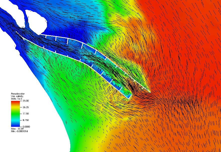
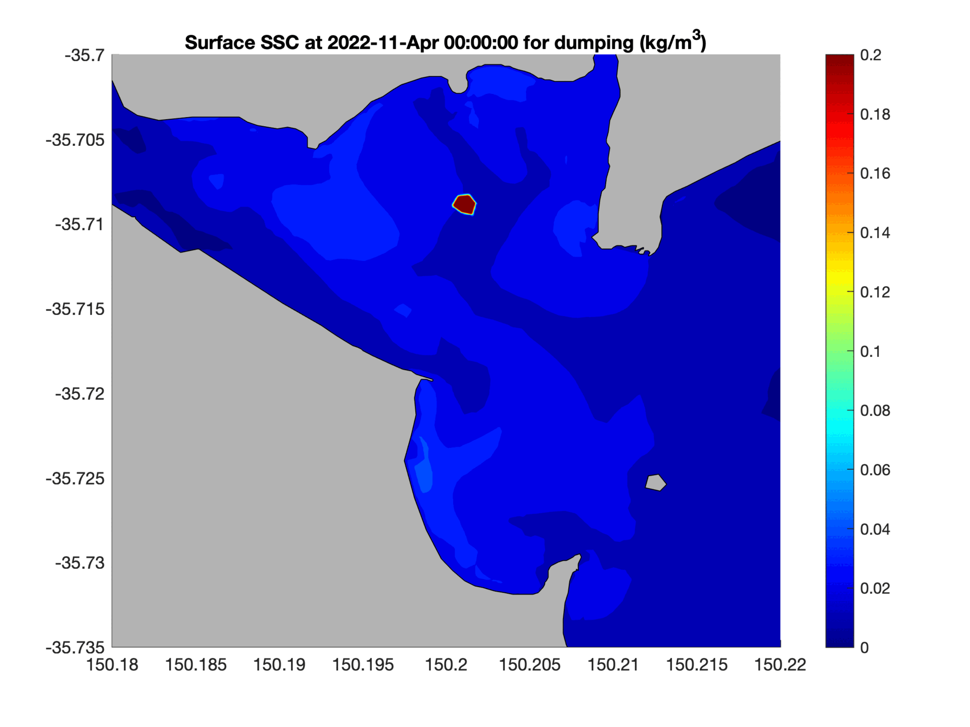
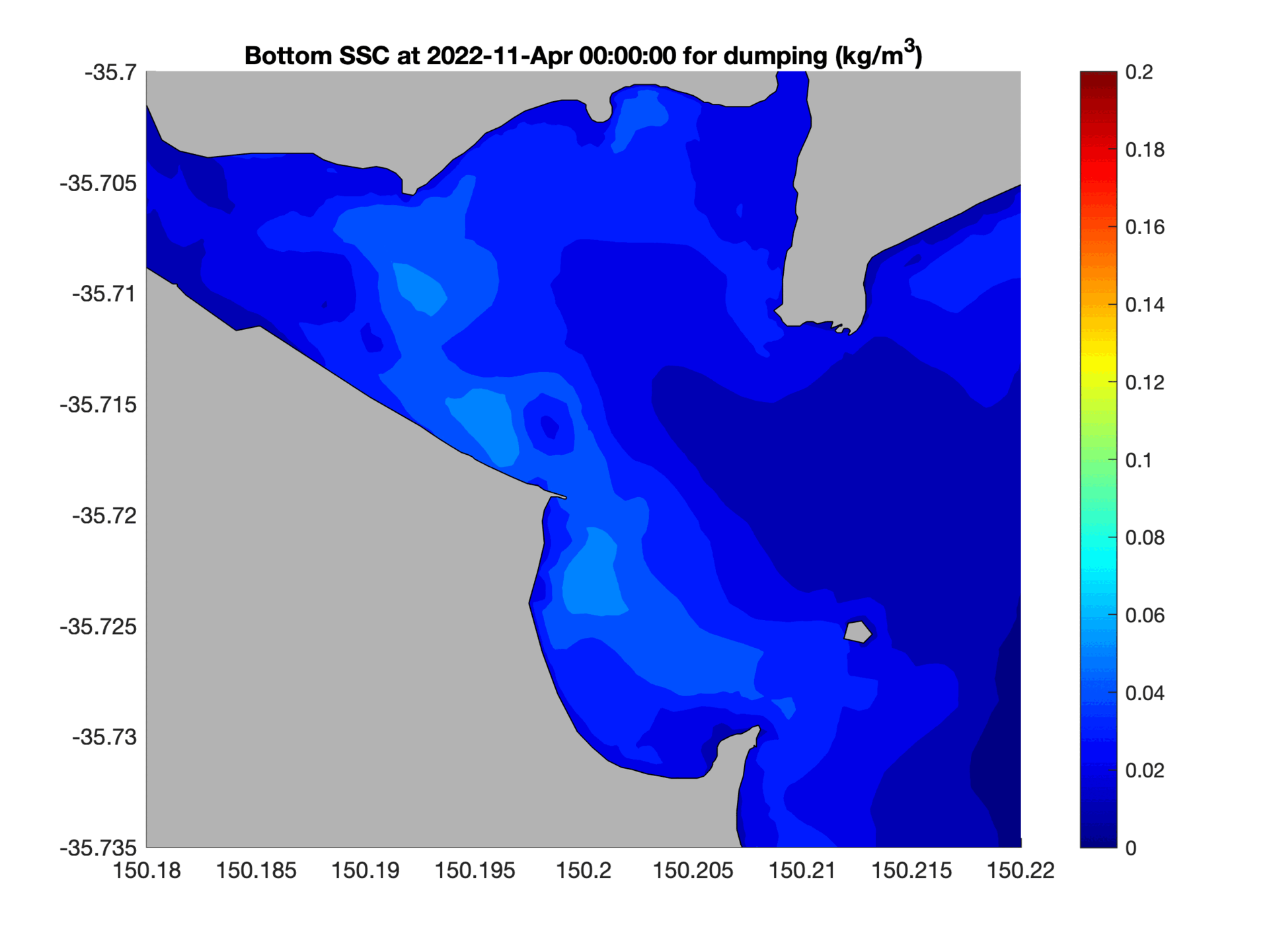
- UNSW-Sed: The UNSW Sediment model is a numerical tool developed by the University of New South Wales (UNSW) to simulate sediment transport and morphological changes in coastal, estuarine, and riverine environments. It integrates hydrodynamic, wave, and sediment dynamics to predict erosion, deposition, and bed evolution over time. The model is widely used for research and practical applications, such as managing coastal erosion, assessing dredging impacts, and understanding sediment-related processes in complex marine systems.
- SWAN: A third-generation wave model, developed at Delft University of Technology, that computes random, short-crested wind-generated waves in coastal regions and inland waters.
- Accurate and reliable predictions for scientific and operational purposes.
- Customizable models to suit specific research or commercial needs.
- Modelling estuarine circulation in Changjiang estuary, China
- Modelling sediment dredging and dumping activities in Batemans Bay, NSW, Australia
Provide tailored marine fieldwork planning based on customer needs and budget, ensuring feasibility and efficiency.
Key Features:
Process:
Benefits:
Examples
Batemans Bay and Sydney Harbour, New South Wales, Australia
Offer a wide range of high-quality oceanographic instruments and equipment for purchase.
Sensors:
Why Choose Us?
Build coastal ocean and sediment models tailored to customer requirements using state-of-the-art modeling tools.
Key Features:
Tools and Frameworks:
Benefits:
Examples